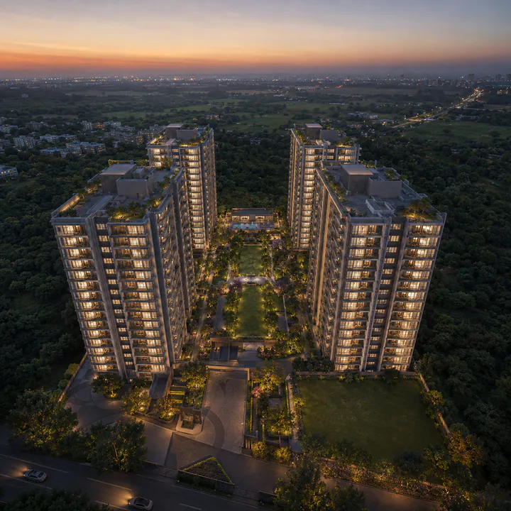
Adarsh Bellahalli Location
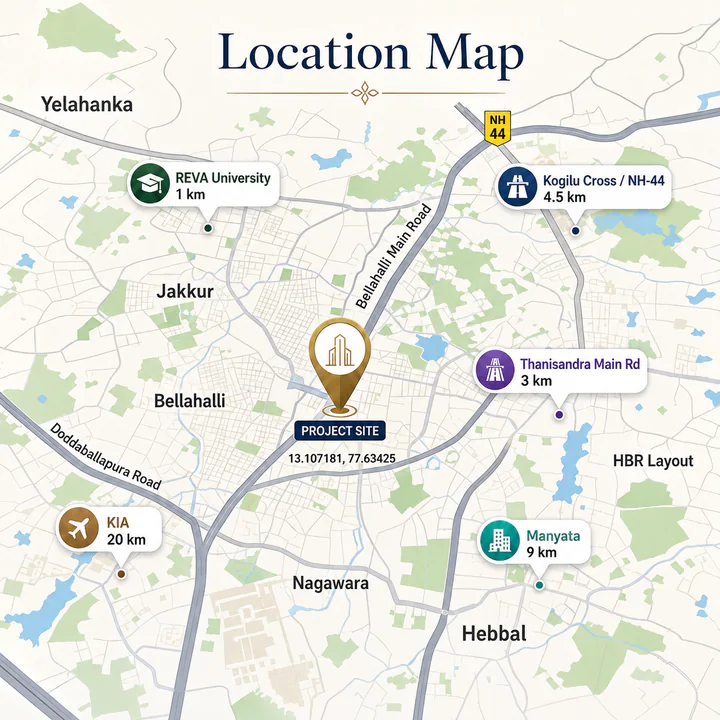
Adarsh Bellahalli sits on Bellahalli Main Road, near the Bellahalli–Mittaganahalli Cross, in the Kogilu pocket of Yelahanka taluk, Bengaluru 560064. REVA University is about a kilometre away. The coordinates are 13.107181, 77.63425, Plus Code 4J4M+VPC. Inside the Bengaluru search area, Adarsh Forest Glen helps buyers keep the map conversation grounded in actual routines instead of only distance claims.
Adarsh Bellahalli on the map
 View on Google Maps →
The address is worth reading carefully, because North Bengaluru is a large and unevenly developed zone and small differences in position translate into large differences in commute. This site is east of NH-44 and the Yelahanka satellite town, west of the Thanisandra Main Road spine, and north of the Hennur–Bagalur arc. That places it inside the catchment of Manyata Tech Park, inside the thirty-minute band of the airport, and within 4.5 km of a Blue Line metro station under construction.
Macro position — the North Bengaluru corridor
North Bengaluru is the city's structurally advantaged growth direction, and has been since the airport moved to Devanahalli in 2008. The reasons are unusually concrete.
The airport anchors an aerospace and hardware economy — the Aerospace SEZ, the Hardware Technology Park, the Devanahalli Business Park, and the KIADB industrial belts along NH-44. Manyata Tech Park at Nagawara anchors the IT and BFSI economy with well over a lakh of workers across its campuses. The Bengaluru Signature Business Park, Bhartiya City and the Kirloskar Business Park fill in between them. The result is an employment base that runs in two directions from Bellahalli rather than one — the single most useful property in a Bengaluru address, because it means a household is not tied to one campus's fortunes and does not commute into the same traffic as its neighbours.
Road infrastructure has kept pace better here than anywhere else in the city. NH-44 to the airport is a six-lane elevated corridor. The Outer Ring Road connects Hebbal east toward KR Puram and west toward Tumkur Road. The Peripheral Ring Road and the Satellite Town Ring Road are the medium-term additions.
Micro position — why Bellahalli specifically
Bellahalli is a pocket rather than a neighbourhood in the formal sense: a cluster of villages — Bellahalli, Mittaganahalli, Kogilu, Kannuru, Chikkagubbi — absorbed into the Bengaluru North City Corporation area and now filling with apartment stock. It sits between the two big established addresses, Yelahanka to the north-west and Thanisandra to the south-east, and it prices below both.
The practical case for Bellahalli over its neighbours is arithmetic. A comparable apartment in Hebbal or Yelahanka New Town costs fifteen to twenty per cent more per square foot. The commute difference to Manyata is five to eight minutes. The commute difference to the airport is negligible. For a household buying on a twenty-year horizon, that spread is the entire investment case.
The honest counterweight is that Bellahalli is still mid-development. Some internal roads are unfinished, retail is thin outside the Bhartiya City cluster, and the pocket depends on Thanisandra Main Road and NH-44 for its arterial capacity — both of which back up at peak. This is a corridor being built, not one that is finished.
Road connectivity
| Route | Distance | Note |
|---|---|---|
| Bellahalli Main Road | On site | Direct frontage |
| Bellahalli–Mittaganahalli Cross | On site | The local junction |
| Kogilu Cross (NH-44 junction) | 4.5 km | Access point to Bellary Road / NH-44 |
| Thanisandra Main Road | 3 km | The eastern arterial to Hennur and the ORR |
| NH-44 (Bellary Road) | 4.5 km | Elevated corridor to the airport, six lanes |
| Outer Ring Road (Hebbal) | 11 km | Connects east to KR Puram, west to Tumkur Road |
| Hennur–Bagalur Road | 5 km | Alternative eastern arterial |
Metro connectivity
The Blue Line is the infrastructure story for this belt, and its timeline is the single most important number in a Bellahalli investment case.
| Element | Detail |
|---|---|
| Line | Blue Line, Namma Metro |
| Alignment | Central Silk Board → Outer Ring Road → Kasturinagar → Nagawara → Hebbal → Yelahanka → KIAL Terminals |
| Nearest station | Yelahanka (Kogilu Cross) — at the NH-44 × Kogilu Road junction |
| Distance from site | ~4.5 km |
| Phase 2A | 13 stations, Silk Board to KR Puram — targeted late 2026, with depot connectivity a known risk that may push to 2027 |
| Phase 2B | 17 stations, the airport extension — targeted December 2027 |
Yelahanka (Kogilu Cross) is designated as the main entry point for Yelahanka Satellite Town and Allalasandra, which means it is planned with feeder capacity rather than as a minor halt. Once operational, Manyata is a 12–15 minute ride and the airport is reachable without a taxi.
Rail and air
| Asset | Distance |
|---|---|
| Yelahanka Junction railway station | ~6 km |
| Bengaluru Cantonment | ~13 km |
| KSR Bengaluru City Junction | ~19 km |
| Kempegowda International Airport | ~20 km, ~30–35 min |
The airport proximity is not a marketing line in North Bengaluru — it is the reason the corridor exists. A thirty-minute airport run without crossing the city is worth a genuine premium to any household with a member who travels for work.
Tech parks and employment
| Employment cluster | Approximate distance |
|---|---|
| Manyata Tech Park, Nagawara | 9 km |
| Kirloskar Business Park, Hebbal | 8 km |
| Bhartiya Centre of Information Technology | 5 km |
| Karle Town Centre SEZ, Nagawara | 8 km |
| Embassy Manyata Business Park (adjacent campuses) | 9 km |
| Aerospace SEZ, Devanahalli | 17 km |
| Hardware Technology Park, Devanahalli | 18 km |
| Bengaluru Signature Business Park, Hebbal | 9 km |
Manyata is the anchor. It is roughly a 25–30 minute drive outside peak, and it will be a 12–15 minute metro ride once the Blue Line is operational. The airport-side clusters run in the opposite direction, which is the point: a two-income household can hold jobs at Manyata and at the Aerospace SEZ and neither one commutes into the other's traffic.
Schools
| School | Approximate distance |
|---|---|
| REVA University | 1 km |
| REVA Independent PU College | 1 km |
| Canadian International School, Yelahanka | 5 km |
| Delhi Public School North, Sahakar Nagar | 7 km |
| Vidyashilp Academy, Jakkur | 5 km |
| Ryan International School, Yelahanka | 5 km |
| Mallya Aditi International School | 8 km |
| Presidency School, Kasturi Nagar / Nagawara | 8 km |
| Stonehill International School, Tarahunise | 12 km |
| Sishu Griha, Hennur | 7 km |
REVA University at a kilometre is the defining institutional neighbour. A large university next door changes a locality's character — it brings retail, food, transport frequency and a rental market for smaller units, and it means the arterial road is maintained.
Hospitals
| Hospital | Approximate distance |
|---|---|
| Aster CMI Hospital, Hebbal | 8 km |
| Columbia Asia Hospital, Hebbal | 8 km |
| Baptist Hospital, Bellary Road | 9 km |
| Cytecare Cancer Hospital, Yelahanka | 6 km |
| Regal Hospital, Yelahanka | 5 km |
| Sapthagiri Hospital, Chikkasandra | 10 km |
| Motherhood Hospital, Hebbal | 8 km |
| Manipal Hospital, Hebbal | 8 km |
Aster CMI and Columbia Asia at Hebbal are the two tertiary-care anchors, both around eight kilometres and both reachable in twenty minutes outside peak.
Retail, food and leisure
Bhartiya Mall of Bengaluru at Bhartiya City, roughly five kilometres away, is the nearest full-scale mall and the largest retail asset in North Bengaluru. Elements Mall at Nagawara is around eight kilometres. Esteem Mall at Hebbal and RMZ Galleria at Yelahanka fill in the mid-tier. Day-to-day retail runs along Thanisandra Main Road and around Kogilu Cross, with the usual supermarket, pharmacy and clinic density that a filling residential pocket generates.
For leisure, Jakkur Aerodrome and Jakkur Lake are around four kilometres, the Yelahanka Air Force Station golf course and the Bangalore Golf Club at Jakkur are within a short drive, and Nandi Hills is an hour north.
Honest trade-offs
Three things a buyer should weigh:
Arterial dependence. Bellahalli's traffic exits through Thanisandra Main Road or Kogilu Cross onto NH-44. Both congest at peak. Until the Blue Line opens, a Manyata commute at 9 a.m. is a 35–45 minute proposition rather than the 20–25 minute off-peak run.
Development stage. The pocket is filling, not filled. Internal road quality varies, footpaths are inconsistent, and some of the amenity a resident wants is still five kilometres away at Bhartiya City rather than five hundred metres away.
A flat twelve months. Bellahalli's apartment prices have moved roughly 0–0.4% year-on-year after appreciating 39.5% over ten years. That is a plateau, and it means the near-term return depends on metro delivery rather than on momentum already in the market.
The investment case
Three catalysts, in order of certainty:
- The Blue Line metro station at Yelahanka (Kogilu Cross), 4.5 km away. Under construction, with Phase 2B targeting December 2027. Metro arrival is historically the largest single step-change in Bengaluru micro-market value.
- Manyata's continued expansion at 9 km. The employment base is established, not speculative, and it is the demand floor under every rental in this pocket.
- The airport economy at 20 km. Aerospace, hardware and logistics employment north of the site continues to build out on land that has already been allocated.
Against that: entry is into a price plateau, the pocket is mid-development, and the metro timeline has slipped before. This is a three-to-seven-year hold, not a trade.
Adarsh Bellahalli Location — frequently asked questions
Next step for Adarsh Bellahalli
Adarsh Bellahalli launches in Q3 2026. Pre-launch registrations receive the configuration and pricing sheet ahead of the public release, priority on floor and unit selection, and direct notification when the Karnataka RERA registration is published.